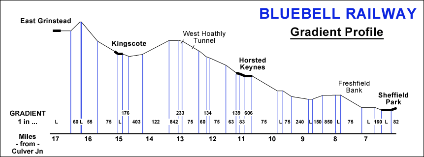

Location Map and Gradient Profile
for the Bluebell Railway


Click on either diagram for an enlargement
See also the Map showing how the line relates to other railways in the locality,
and track plans of the stations: Horsted Keynes, West Hoathly and Kingscote.
Aerial photographs from the 1940s covering much of the line are also available.


Return to BRPS Home Page,
to the Timetable or to Special
Events
Visitor Info. -
Museum -
Trust -
Catering -
Contacts -
What's New -
Projects -
Locos -
Carriages & Wagons -
Signals -
History -
Other -
Links -
Search -
FAQ
Why not become a BRPS Member? -
Get more involved as a Volunteer
Your ideal Film/TV location?
 Location Map prepared for computer display 31 January 1996, and Gradient Profile re-drawn 22 March 2013 by Richard Salmon.
Based on original drawings by Robin White, used with permission.
Gradient Profile to the South of Kingscote modified in accordance with Les Haines survey.
Page last updated 22 March 2013 by Richard Salmon.
© Copyright BRPS. Privacy Policy
|


